


Blupix - Crowdsourced flood Depth estimation
(Work in progress)
BluPix is a crowdsourcing application for collecting pre- and post-flood photos of submerged stop signs for flood mapping in urban and rural environments. Collected photos are analyzed using image processing and deep learning techniques to calculate and display geotagged floodwater depth information at the street-level.
My Role
Product Designer
Timeline
Aug 2024 - Present
Context
NOAA Funded Project
IRB Approved
Mentor : Dr. Amir Behzadan
Product Challenge
Usability:
The app should be simple enough for both emergency personnel and regular people to use with little to no training needed.
Accuracy
To measure stop sign pole lengths accurately, the light object detection model needs to function well in a range of weather and lighting scenarios.
Reliability
In the event of a flood, Blupix must continue to operate dependably even in the face of possibly erratic network conditions or restricted access to cloud services.
Ensuring that data submitted by the general public is correct, usable, and unaffected by improper user input or device malfunctions is known as crowdsourced data quality.


Impact
Enhance decision-making during flood emergencies
Real-time data from the app could help emergency teams allocate resources more efficiently.
Improve public safety
Individuals can better assess whether areas are safe to navigate during floods, potentially reducing casualties and property damage.
Advance flood monitoring research
Data collected through Blupix could be valuable for researchers studying flood patterns, helping refine flood models and improve prediction accuracy.
Initial Research
Target Users
Urban and Rural Residents in Flood-Prone Areas
Emergency Responders and Rescue Teams
City Planners and Government Authorities
Drivers and Commuters
Research Methods
Primary and Secondary Research online
Interviews
How Might We Questions ?
01
How might we empower users to quickly and accurately assess floodwater depth using their smartphones in real-time?
02
How might we ensure the app provides reliable and actionable information for individuals in flood-prone areas to make safe decisions?
03
How might we design an intuitive and accessible user experience that accommodates diverse users, including emergency responders, city planners, and everyday commuters?
Wireframes and user flow

Splash screen

Home screen displaying filters and pins of previous flood images from users

Buffering status screen


Disclaimer enclosing the data being collected
Algorithm fetches the data and performs a comparison

Floodwater depth and secondary data is displayed of the 'Pair' the user can choose to share this with the community and also share it through messages and social media
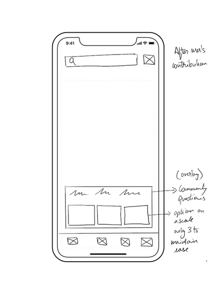

Final Home screen after the user's contribution
Expected Results
Usability Insights :
Identify pain points and improve task flow intuitiveness.
Future Foundation :
Highlight further research opportunities and establish benchmarks.
Validation :
Confirm prototype effectiveness and research assumptions.
Design Enhancements :
Recommend actionable interface changes based on usability tests.
User Needs :
Understand preferences of flood-experienced vs. non-experienced users.

Version 1
User Interviews
Method: Zoom / In-Person
Date: Jan 22 - March 22
Sample Size: 50 users
We seek to understand...
-
What are frustrations users have during flood event.
-
Does the user prefer technology during an emergency?
-
What are the user’s thoughts on the first version of the blupix protoype.